Idk why but when I type that, it doesn’t sound good. Not to be like, “duh, it’s Alzheimer’s,” but It sounds like he has it. As if he’s defective for having a neurodegenerative disorder. And I can see why technically, that can be said but I don’t like the connotation that surrounds Alzheimer’s. Because with any bad, can come the good, and why do we fail to see this?
There’s a stigma that surrounds having a disease where it’s instantaneously thought of as not a good thing. And I’m not saying it is a good thing, but I am saying it’s not always bad. And that’s the problem. Because even on the days when my dad is a bit off, he still has his bright and shining moments.
For instance, today, Tuesday, August 13, 2024. I popped into the TV room where my dad 98% of the time is and I asked him what he was doing. He instantly said “Reading about the Spanish Civil War of 1936.” And he proceeded to tell me about the heinous acts that took place. As he is telling me certain things, his face gets red and his eyes swell.
He has reading glasses on but I can see through them that his eyes are tearing up. He is so hurt that people were filled with so much hate that they needed to harm a group of young girls walking to church and kill over 6,000 priests, all for what? Now, you might think anyone might have that same reaction but I wouldn’t be writing this if it weren’t a special case for my dad. My dad is the son of a Polish World War II survivor, Waleryian.
Waleryan was a Polish resistance fighter who fought for his survival on numerous occasions and eventually succeeded. The stories my dad was told as a child could make anyone shudder. From a young age, my dad would tell us about the atrocities that took place at the concentration camps and villages. Never did he shed a tear. He always remained stoic. His stories were not absent of violence against children or priests, in fact, they were frequent.
So, when he sheds a tear telling me about what he recently read—it tells me so much. It puts into reality how much his brain is shifting and the effects it has on his emotions.
It tells me he can still focus on something, dive into it, and recite it. This helps me see that this part of his brain is still active. One of my favorite parts about my dad was his intellect. He has never once been excited about sports, gossip, or the traditional things parents talk about. He always loved talking about history and the sciences. Instead of watching Family Guy, an NFL game, or The Simpsons… we would be channel hopping between Antique Roadshow and Star Trek. I was raised with whatever was on National Geographic, Discovery, and History channels. And I love that he still has that. I never truly held an appreciation for it when I was younger, but now I do and I’m happy to relive those times again.
It also helps me see his emotions. Growing up and never seeing my father cry, never shying away from telling me things that other parents would probably shield their kids from—like who Charlie Manson or Josef Mengele were, and just being stern and put together while talking about them—it does something to you. Having been raised by him, I share many of his interests and although I am not as stern or stoic as him, I was a bit devoid of the human aspect towards certain things people would normally not want to talk about, like cult leaders and human experiments. His newfound ability to cry while reading or watching certain things makes him feel more human. It helps me understand the magnitude of what he’s researching which helps me be more sensitive.
So I guess I’m trying to say that no matter how small it might be, always look for the light. This is one of those moments where I feel special that he’s telling me certain things. At the end of the conversation, he said, “Well thank you for listening to me” and I said, “of course. I’m happy to” and I know it means a lot to him. And I truly am happy to listen to him. Because now things are different. I can tell he needs someone to listen.
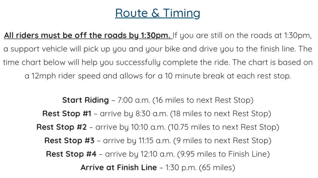
Insights from someone who never really hopped on a bike before Philly to Atlantic City | Level: Challenging fun
Let me start by saying I am not a cyclist. I found myself in this position by having very athletic friends that like to take on various challenges and new things.
Prior to 2023, I really hadn’t ridden a bike before. I bought a hybrid mountain-road bike in the pandemic thinking I’d get into it. I rode it one time for an 8-mile loop. And that’s only because I got lost and couldn’t find my way back or else it would’ve been a 3-mile loop.
My friends had done the Ben to the Shore Bike Tour (the Tour) last year, in 2022. I didn’t sign up but went down with another friend to the finish line to greet them when they were done. The atmosphere was like nothing I had experienced before. After the half marathons I’ve done, most people look defeated when they cross the finish line—even if they’re happy, all of the stress they put on their body shows (or at least it does for me). The riders crossing this finish line had fun team uniforms, were playing music, waving and cheering. You could really feel the excitement they had for being there and the sense of accomplishment a 65-mile road race brings.
I wanted to tap into that energy and try something new. Biking had always caught my eye – the freedom you feel when on a bike, the distance you can cover in a short amount of time and of course, getting to finally scope out one of those beautiful bikes I always see in Instagram posts.
Photo courtesy of Anton Krupicka Instagram’s page. Might be me, but just look at how sexy that bike is.
About the Ben to the Shore Bike Tour
The Ben To The Shore Bike Tour is a charity event to raise funds for Families Behind A Badge Children’s Foundation, a group dedicated to financially helping the families of fallen or critically injured first responders. The route covers 65 miles from Philadelphia, PA to Atlantic City, NJ. This year there were over 2,000 riders, including one guy who did half the ride on a unicycle.
Training
When my friends sent out a group text letting us know they were signing up for this year’s race-I got amped. I wanted to sign up but held off because I knew I wouldn’t be able to keep up with them. But a month or so later, my other friend said she’d do it with me, so we signed up together.
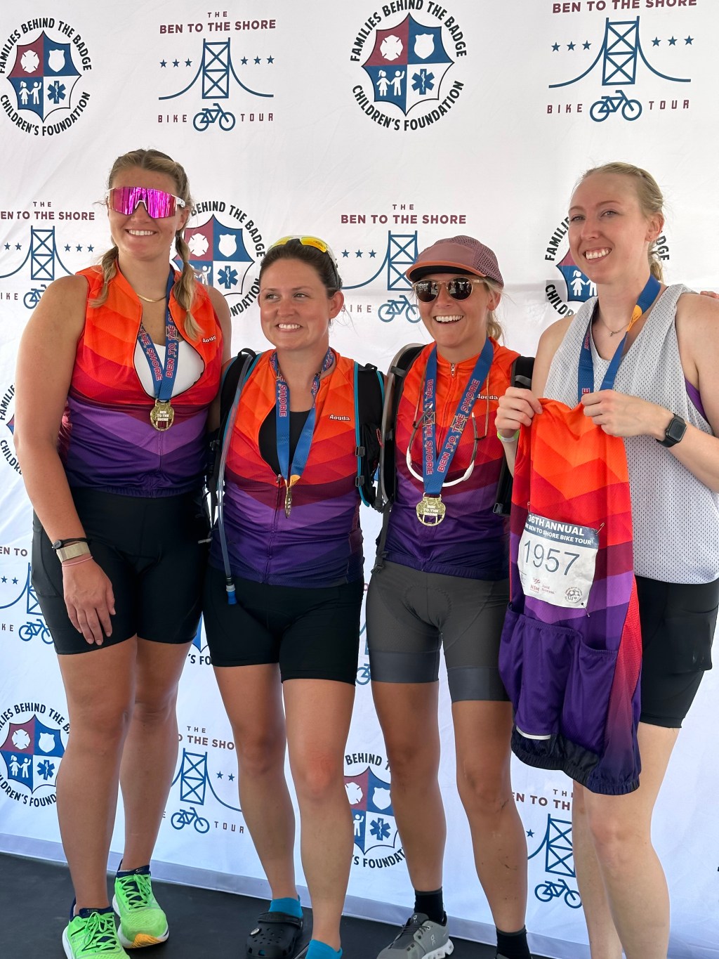
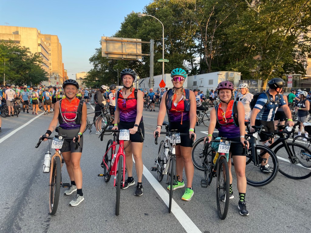
The Wheelie Good team was officially made of 4 amateur riders ready to Tour the Shore.
I have to be completely honest, training for us wasn’t that intense. It should’ve been, but it was hard to find time to get a long ride in. We first got our hands on bikes that weren’t rusted hand-me downs.
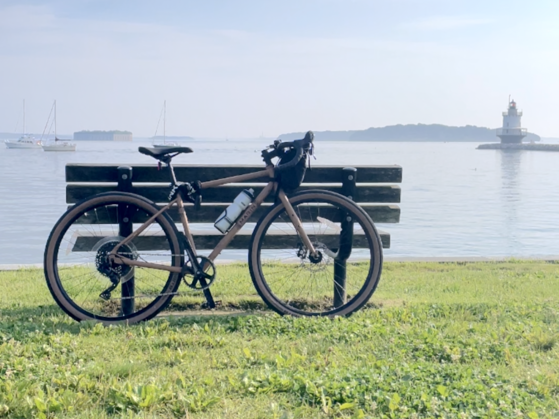
I love my bike. I traded in my old one at Fairmount Bicycles on Fairmount Avenue in Philadelphia. She’s not only a Marin Nicasio Plus, but my newfound pride and joy.
Individually, we would ride short distances between 2-17 mile stretches about once a week, starting at the end of May. But when we could meet up with someone else, we’d do a longer route.
The first was 21 miles along the Delaware Canal Towpath. We went from Washington’s Crossing up towards New Hope and back.
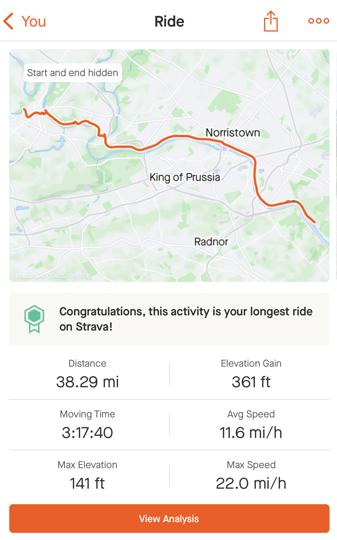
The third was 38 miles along the Schuylkill River Trail. We went from Conshohocken to Phoenixville and back.
That was all. We only did three longer routes before the big day.
As for other ways we prepared—I didn’t really do too much else aside from the shorter rides (about 1-2x a week), taking long walks (about 3-6 miles 3x a week) and trying to eat healthy. My friends did some cross training with running and lifting. I should’ve tapped into strengthen training as well.
Safety check & bib pick-up
When I bought my bike, it came with a free 30-day tune up. About 2 weeks before the race, I brought it to Fairmount Bikes and an hour later it was back in my hands. I could’ve printed out a form for them to sign-off on for the mandatory Safety Check but I knew I wanted another look at it closer to race day. I rode it another 20ish miles before bringing it to an authorized Safety Check dealer.
3 days before the Tour, I brought it to Bike Works in Doylestown. Within 10 minutes, they did what they had to do, slapped an orange band around the handlebar stem and it was ready for race day.
You could pick up your bib packet starting on the Thursday evening before the race.
My friend picked all four of ours up on Saturday with no hiccups. In the packet were:
Instructions
2 bibs: one for your shirt and one with live tracking
2 bracelets: one for the after party worn on your wrist and one with an emergency number that went on the bike
Your shirt
If you had a safety check done by a retailer not authorized by the Tour group, you needed to bring the form they filled out. Then, you got a 3rd bracelet that went on your bike.
Night before and morning of
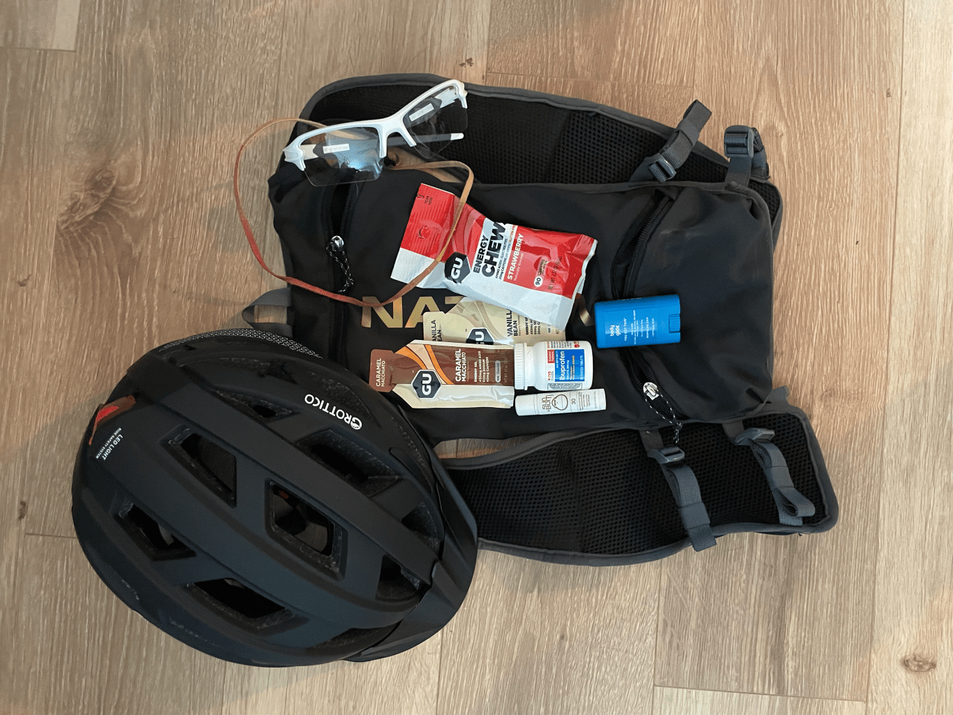
The night before the Tour I prepped my bike and everything I was bringing with me. I had 2 water bottles/cages on my bike along with a hydration bladder pack. I stuffed 3 energy packets, $40 in cash, my ID and sun screen lip balm into the pockets.
Then I met up with my two teammates for a nice Italian meal. I had bacon brussel sprouts and chicken francese over linguini pasta with a water bottle filled with Liquid IV. When I got back to my apartment, I had to wait for my other teammate to come over before heading to bed. We didn’t fall asleep until midnight but thankfully, got a good night’s rest.
Day of the Ben to the Shore Bike Tour
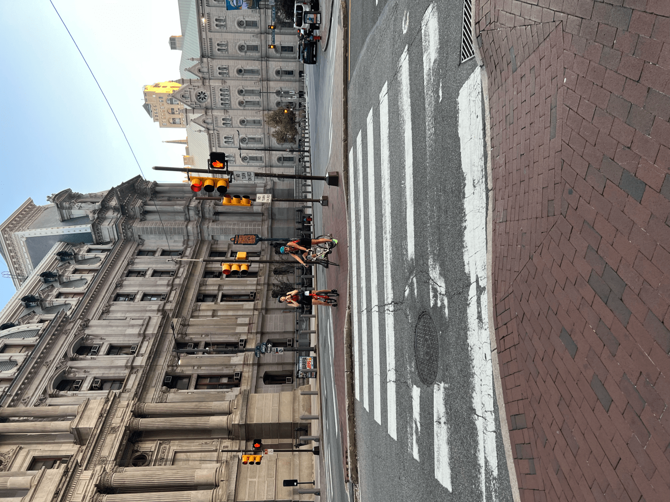
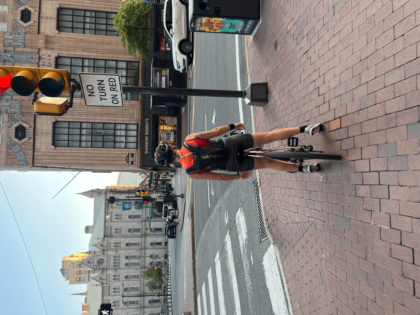
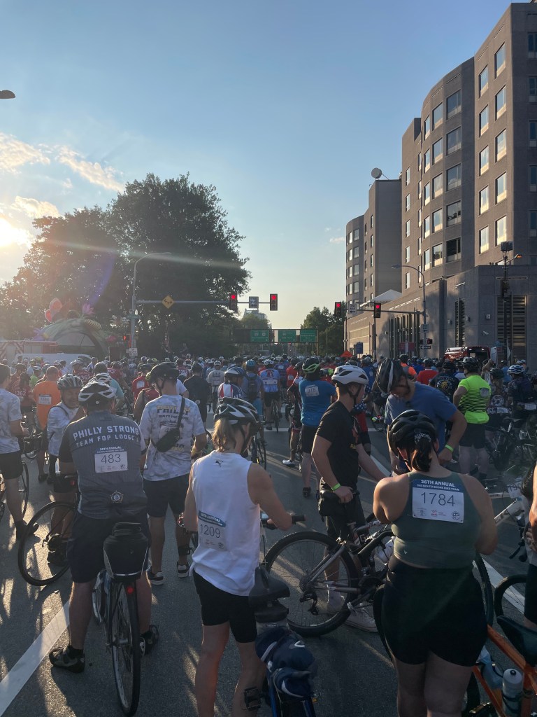
We woke up at 5am to get the day started. I had a banana, water and a stinger waffle. My friend had a banana and a bagel with peanut butter. We took Ibuprofen and applied body glide to wherever we could. Once we were ready to go, we headed towards City Hall and then made our way to the starting area at the base of the Ben Franklin Bridge.
Man oh man, was it packed. We were nestled on Race Street where we stretched, took some pics, chatted with fellow riders and filed into the starting gates.
Fun fact: Race Street was originally named Sassafras Street but was renamed in the 1800s because it was regularly used for horse racing—how fitting for the day.
It’s go time
My two teammates peeled off and went ahead while my other teammate and I stayed together. The first stretch takes you across the Ben Franklin Bridge, then into some hills throughout Camden and Haddonfield areas before bringing you through the Pine Barrons and dumping you in Atlantic City. It was about 75 degrees when the Tour began at 7am. The temp was expected to climb to a cool 88 degrees as the day went on.
The Tour had 4 rest stops, all complete with water, Gatorade, fruits and granola bars. They had halved bananas and little cups of blueberries, which was an unexpected treat.
We stopped at rest stop 1 to quickly adjust ourselves and check-in with each other. We got back on the road and as we approached rest stop 2, I knew it was time to stop. There were some hills along the way that were bigger than we anticipated. As we pressed on, we passed rest stop 3, hoping to gain some ground until rest stop 4. During these 9 miles, I realized how much I’m going to really have to push myself. My body was shaking, left leg was burning from lactic acid build up, right leg felt off (a sprained ankle and recovery ACL will do that) and I wanted to puke. I had to stop myself from thinking too into it and the only thing keeping me going was knowing I had rest stop 4.
At stop 4, I binged on ice, gatorade, blueberries and the tastiest Smucker’s peanut butter and jelly Uncrustable I’ve ever had in my entire life. After a 5ish-minute rest in the shade with ample nutrients back in the system, we started into the coastal headwinds eager to complete the ride.
That rest stop was the pick-me-up I so desperately needed. You could feel spirits being lifted knowing we were about 10 miles to the finish line. Groups of cyclists would be cheering each other on as we waited at traffic lights.
You could see Atlantic City appear over the bay and I think everyone that I was with got a second wind in their system. With 5-miles left and stand-still traffic to our left, I told my friend I had to play music to get that extra bump of motivation going to peddle faster.
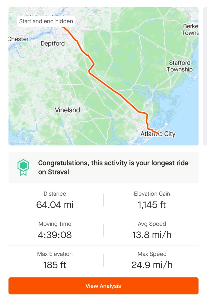
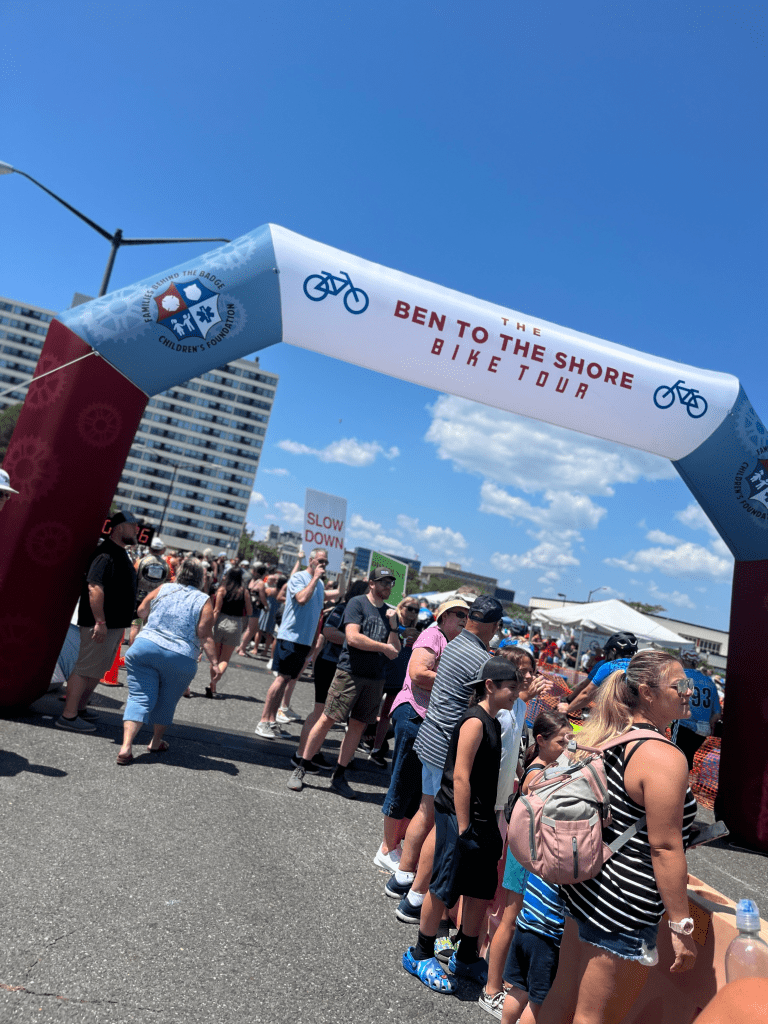
As the road straightened into the arch over the finish line, we began passing people. Shortly after 12pm, we crossed over and completed the 65-mile journey from Philly to AC. Our elapsed time of 5:14 and moving time of 4:39 was better than I thought I’d do. My original goal was to complete the ride by 1pm, 12:30pm if I got lucky. My teammate and friend totally could’ve completed it ahead of me, but I’m thankful she stayed by my side. I can’t say for certain that I wouldn’t have been able to do as well as I did if it weren’t for her company, but I can say that her presence helped me continue onward.
The after-party was at The Showboat parking lot. They had some of Wawa’s best packaged food items like wraps and pretzels, Termini Bros cannoli’s, water, iced tea, cold beer, merch and music. For anyone that wasn’t a rider, it was $20 to get in. They also had a trailer with pictures of fallen police officers and first responders to remind everyone why they were riding.
Take away
I viewed this race as an opportunity to challenge myself, doing something I never thought I would actually get into—cycling. Even though I’ve completed other races, this was the first time I felt a real sense of accomplishment. I cried at rest stop 4 (into my uncrustable) because I knew I was going to complete this ride, pushing through saddle soreness and the aches and pains of my body.
In total, we raised $1,360 for the Families Behind the Badge. I already plan to sign up again, with more training next round. I believe registration will open in February 2024.
If you’re interested in signing up, but aren’t sure if you’d be able to do it. Please know that you can do it. People of all ages, fitness and preparedness levels were out there along side you. At the end of the day, it’s all for a great cause. Enjoy yourself, listen to your body (there are emergency vehicles and guides along the route if needed) and don’t stress. You’ll have a wheelie good time.
The Delaware Water Gap’s finest Knowlton Township, New Jersey | Level: Easy-Moderate
Background Chat:
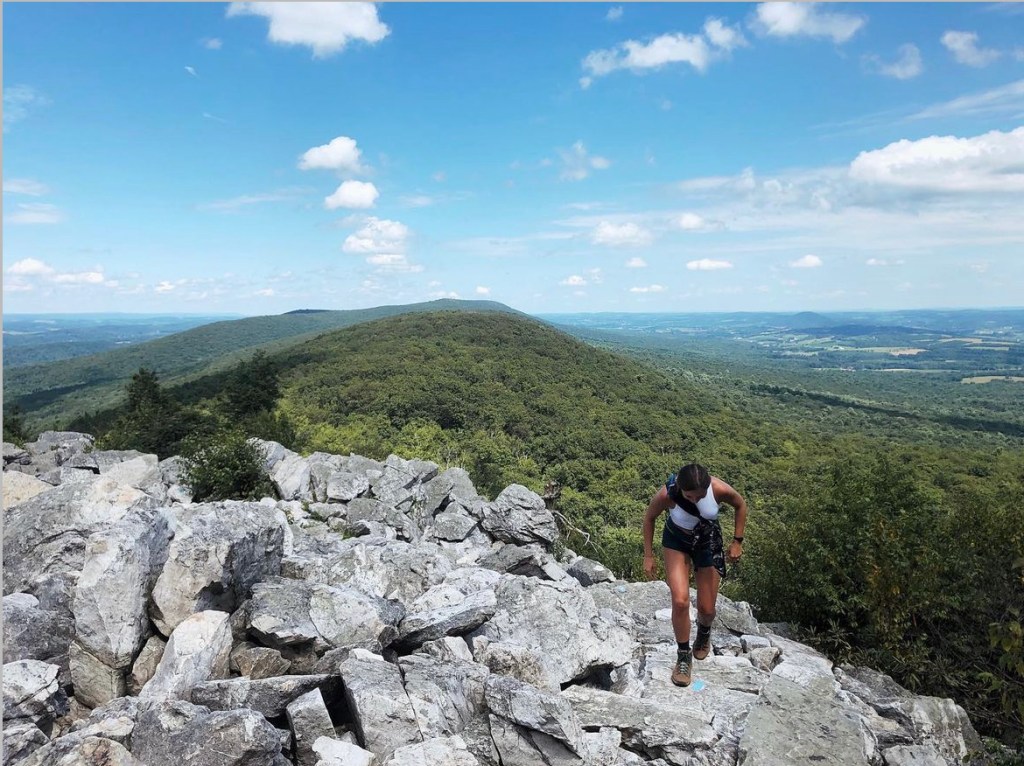
If you’re located in Philadelphia or the surrounding suburbs, the elevation of hikes in the area is modest at best. That is why Mt. Tammany is my go-to spot for a relatively quick challenge with a view. It’s also dog-friendly, so I love to bring Merlin with me. It’s my favorite “big” hike to take him on because it’s enough for him to get his Aussie energy out but not too much that I’m over-exerting him.
Mt. Tammany is located in Knowlton Township, Warren County, New Jersey. It’s the southernmost peak of the Kittatinny Mountains and is part of the Appalachian Mountains. At 1,526 feet tall, it forms the eastern side of the Delaware Water Gap, with Mount Minsi across the way in Pennsylvania.
The hike:
This 3.6-mile loop can take between 2 and 4 hours to complete. It can be done in either direction, but I suggest going counter-clockwise, starting with the Red Dot Trail and ending with the Blue Dot Trail (Pahaquarry Trail). When you start, you’ll make your way up a casual incline to the iconic viewpoint. It overlooks the Delaware River and Mt. Tammany’s sibling, Mt. Minsi.
Then, you’ll continue onward and upward, eventually meeting a section that requires scrambling up a steep rock face. In my opinion, this scramble is best done going uphill. Shortly after, you’ll reach the summit. Although it might be crowded depending on the day, it’s a great area to rest and grub out. I will say, don’t get your hopes up for a spectacular view, but you might still end up seeing a hawk or an eagle!
When you’re ready to continue, you’ll begin going westward on the Blue Dot Trail. This trail is more of a gradual decline, but a long one. When no one is around, I’ll take Merlin off the leash as he loves to run down it. Eventually, you’ll pass a swimming hole and a few beautiful waterfalls. I have personally not gone swimming in the swimming hole, but I have seen people doing it and heard life jackets are recommended.
You’ll make your way over a wooden bridge and hike along the Dunnfield Creek. This is the flat, relaxing part of the hike. Beware though, it’s pretty wet in this section. After a short walk, you’ll be back at the parking area!
Alternatives when you’re in the area:
If you’re looking for something shorter, you can always skip Mt. Tammany and walk along Dunnfield Creek to the swimming hole. Just follow signs for the Blue Dot Trail (Pahaquarry Trail) or Dunnfield Creek. You can also stop at the Kittatinny Point Visitor Center and walk along the Delaware River. There are picnic tables and plenty of green spaces for relaxing.
Getting there:
It’s about 1 hour and 45 minutes from where I live in PA and about 2 hours from Philadelphia. You drive through adorable towns and beautiful landscapes, making it worth the drive. Put on a good podcast or playlist, grab a snack, enjoy a bevy, and mentally prep for a hike that’ll leave you feeling you accomplished.
There are a few areas to park that are all easily accessible right off of Interstate 80. There are two lots, one for the Dunfield Creek Natural Area Trailhead and one specifically for the Red Dot Trail. Follow signs for the Dunnfield Creek Trailhead parking area. If those are full, you can also park at the Kittatinny Point Visitor Center.
These lots can fill up quickly on warm weekends, so it’s best to arrive early (before 11 am) or after 3 pm. If you go later, please make sure you are equipped to return to your car in the dark, depending on the time of year you go or how late you plan on staying.
Helpful tips:
Hiker shuttle: If you can’t find parking or want to make a full day trip of your time in the Gap, there is a shuttle service. I have not taken it before, but you can learn more about the Connector Shuttle service on the Go MCTA website. For quick reference, here’s the map and transit schedule.
Restrooms: As of August 2023, there were porta-potties at the Dunfield Creek Natural Area Trailhead. Although the Kittatinny Point Visitor Center is closed, the toilets there are open.
Rest stop: The Delaware Water Gap Travel Plaza is on Rt. 80 W, about 5 minutes from the trailhead.
Trekking poles: These aren’t necessary, but if you find them helpful, go for it! This is a great hike to get acclimated to rocky terrain, build endurance, or for conditioning.
My first time hiking the Franconia Ridge Loop was May 31, 2020. It was at the height of COVID-19, and I had recently been laid off from my job working for an international NGO/education exchange organization in Vermont. In the same week that I was laid off, I was also broken up with and my uncle passed away.
Although it was a challenging time, I felt like doors had opened for me. I wasn’t necessarily in love with my job, the town I lived in, or even happy in my relationship. What happened was life giving me the push I needed to say goodbye to the parts of my life I had outgrown (minus my uncle’s passing—miss you, Uncle Bob). It was time for me to set forth on a new path.
Thankfully, I had an awesome landlord who understood my concern about being able to make rent payments amid a global pandemic and unemployment. He let me end my lease early on July 1 so I could move back to Pennsylvania and in with my parents.
My time in New England was now limited. When I first moved to Vermont, I told myself I would get into hiking, but nearly two years later, I still hadn’t made time to explore it much or the nearby White Mountains. It was truly now, or who knows when.
I started searching for hikes that would help me gain a sense of accomplishment, disconnect from the world, and teach me something about myself. My brother is a fairly experienced mountaineer and spoke highly of his times hiking the Presidential Traverse. After doing my own research, I knew I wanted to tackle it that summer. I told my brother about my goal and he suggested the Franconia Ridge Loop as a starting point.
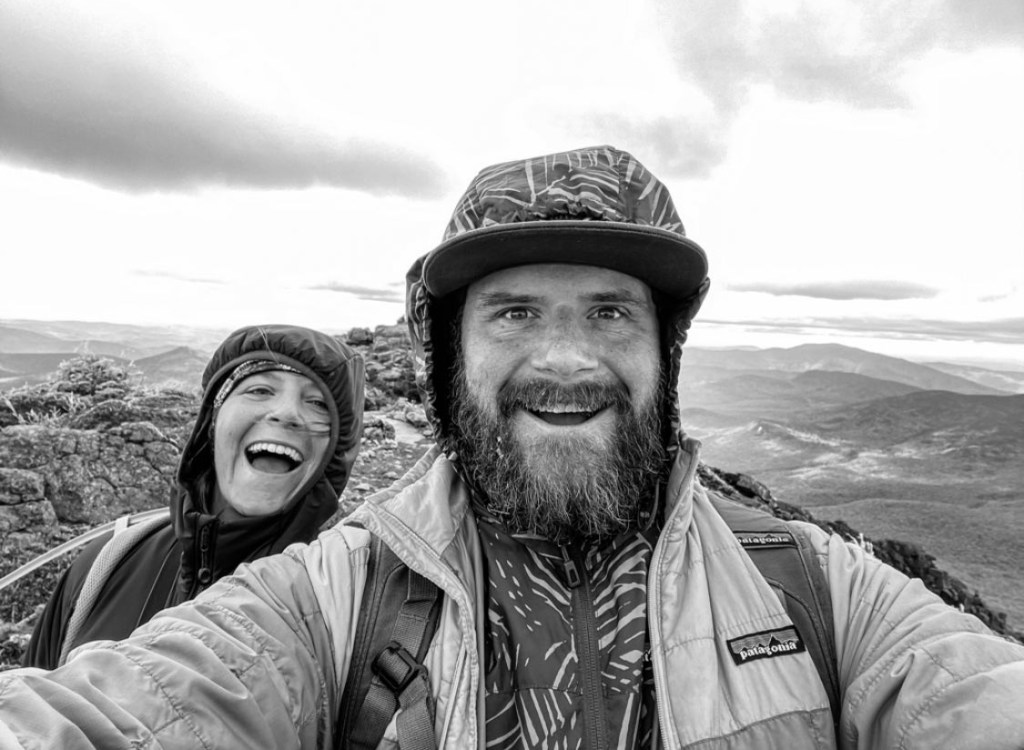
The 8.8-mile loop, which hosts about 4,100 feet of elevation gain, would help me become more familiar with the various terrain and weather in the Whites. As I started to plan my trip out, my brother grew envious. He lives in New York City year-round but has a cabin in Maine, where they had been quarantining since April. I offered for him to join me and he jumped at the opportunity. We made sure we had layers that would keep us warm, snacks that wouldn’t get rock hard in cold temps, hydration, and good footwear.
The Hike:
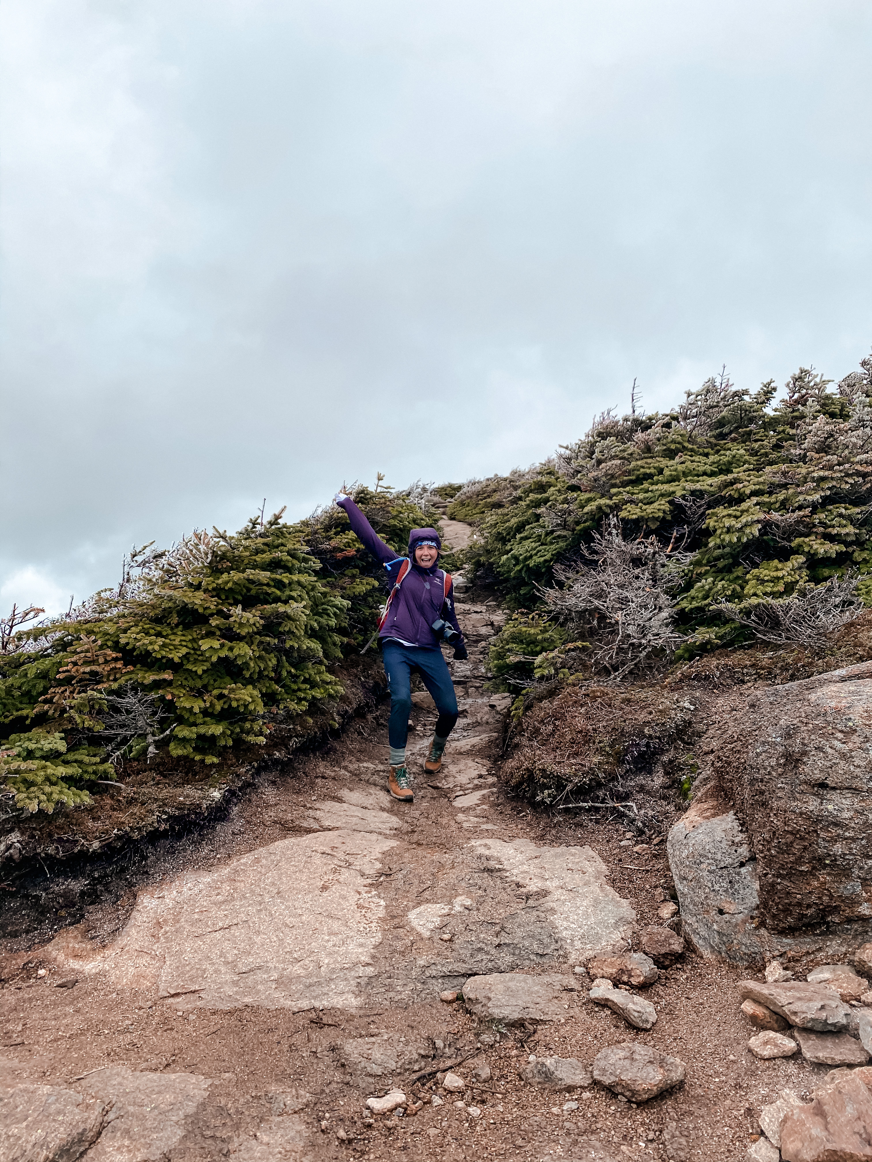
I made the 2-ish hour drive starting at 7am from Brattleboro, VT to Franconia Notch, NH. We met at the Bridle Path Falling Waters Trailhead and the parking lot was pretty packed. If you get there and can’t find a spot, there is another lot across the street at the Lafayette Place Campground. Almost right when we got there, shortly after 9am, we took off.
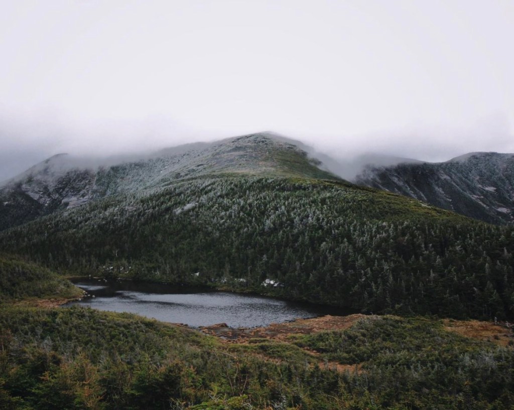
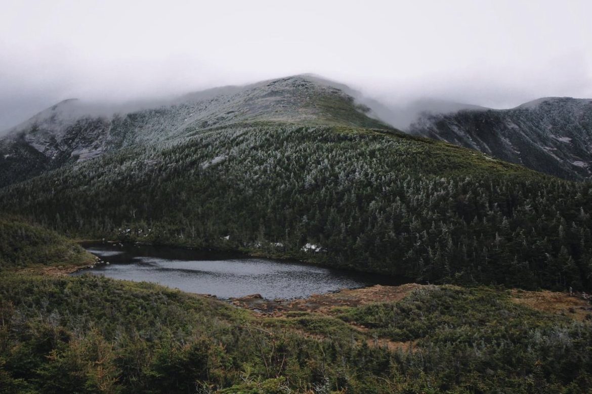
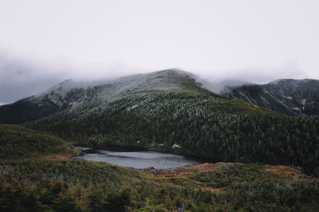
The complete loop encompasses the Old Bridle Path, Greenleaf, Franconia Ridge, and Falling Waters trails, along with three peaks, Mt. Lafayette, Mt. Lincoln and Little Haystack. We started clockwise, going up the Old Bridle Path for a more gradual uphill start and to enjoy the 3 waterfalls on the way back.
It was a muggy but chilly start. Conditions were cloudy with a high for the day around 60 degrees. The trail can be difficult, especially in May, with patches of snow, slippery sections and high river crossings. We packed Microspikes in our daypacks just to be safe but thankfully, didn’t end up needing them.
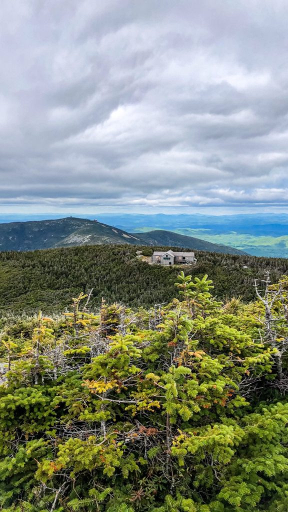
The Old Bridle Path is a 3-mile long trail that will bring you to the GreenLeaf Hut. While ascending the Old Bridle Path, you’ll encounter remarkable vantage points of Mt. Lincoln and Mt. Lafayette.
The first two miles of the trail are fairly gradual, allowing for a quicker start. The final mile of the trail is steep, with large granite rock slabs and boulders. This is the section that if conditions are slick, you will want to proceed with caution. Old Bridle Path will bring you to the GreenLeaf Hut and if it’s open, stop by to refill water or purchase baked goods and snacks.
As we got closer to the hut, the winds started to pick up and temperatures started to drop. Since it was during the pandemic, the hut was closed, but we sat on a bench with the hut blocking us from the wind. We fueled up with sport beans, cosmic brownies and pepperoni. We put on an additional layer under our jackets. My brother didn’t bring a pair of gloves but I did, and boy was I happy I did.
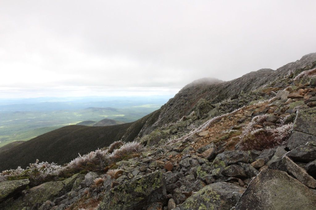
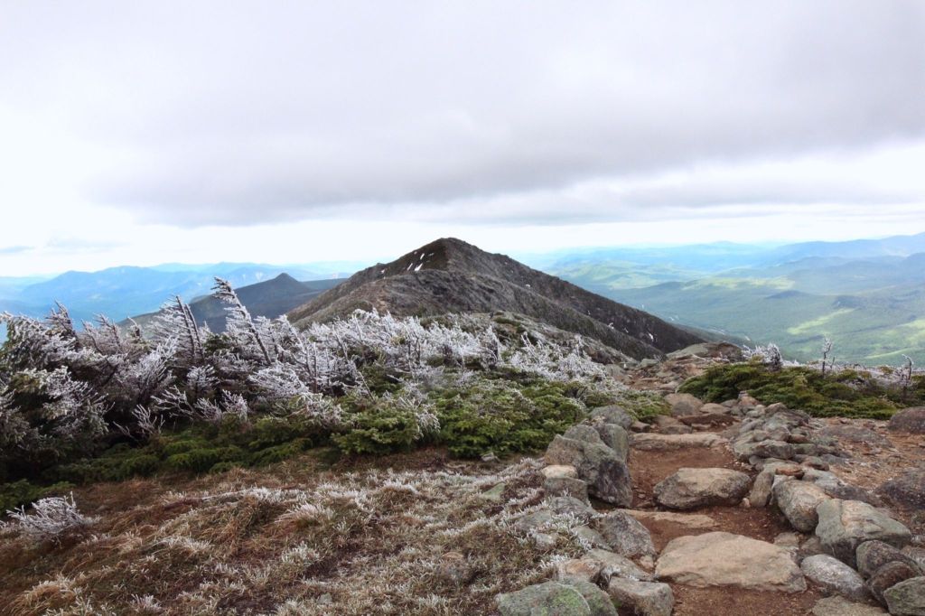
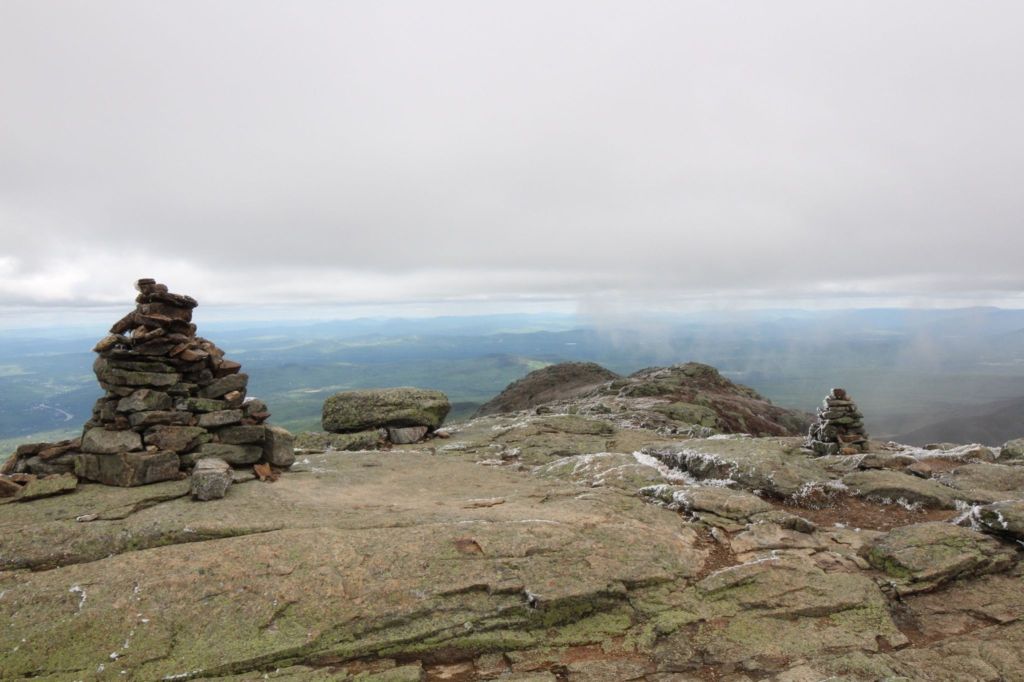
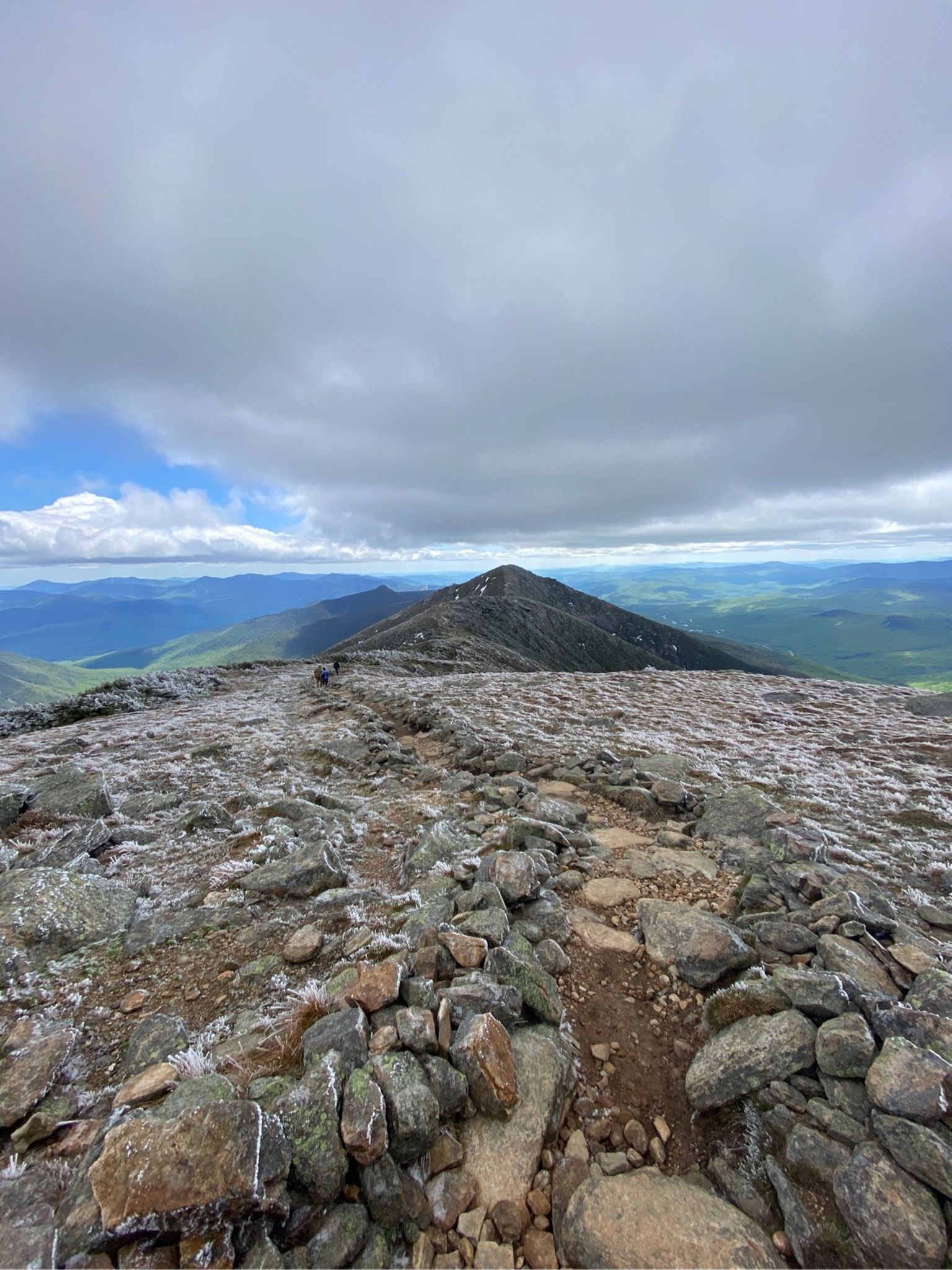
At the hut, Old Bridle Path turns into the Greenleaf trail. You’ll continue on that for about 1 mile until you hit Mt. Lafayette. The Greenleaf Trail is faily rocky and can be a steep ascent that’s mostly exposed. You’ll begin to see rocks and Carins burried in rime—a type of ice that forms when the moisture in fog freezes suddenly on an object.
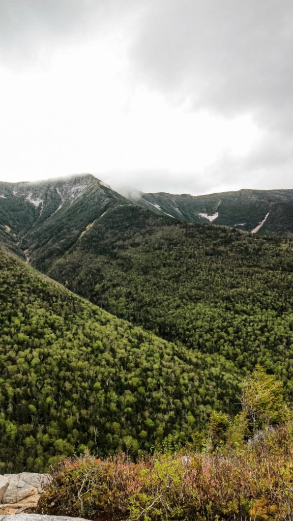
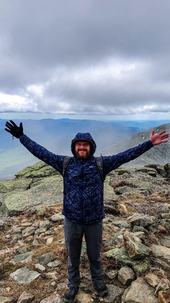
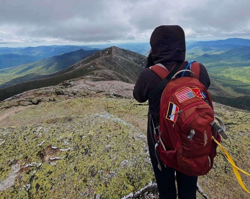
Once you hit Mt. Lafayette, you’ll be on the Franconia Ridge and above the tree line for more than a mile and a half. You’ll be exposed to the elements, which is why the Franconia Ridge is not only known for it’s breathtaking views of the Pemigewasset Wilderness, but also for its treacherous weather. I ended up lending my brother one of my gloves to give him a little more protection against the elements. The Ridge offers a bit of a break from steep ascents and descents but does host a few scrambly spots. You’ll continue on it until you hit Mt. Lincoln and then Little Haystack. You’ll also find some great photo op spots.
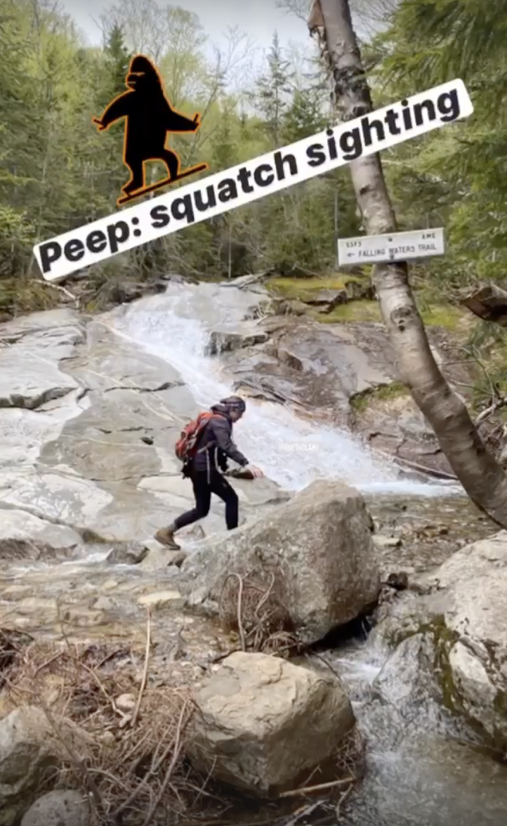
From Little Haystack, you’ll start the steep descent down the Falling Waters Trail. The hardest section is relatively short and happens at the start of mile 7. It’s steep switchbacks that for us, were actually very slick. We moved slow and steady. I didn’t bring trekking poles at the time (I didn’t own them then) but they would’ve been very helpful.
We passed a few adventurers struggling to make their way up the Falling Waters Trail. It was about 1:15pm and they were dressed in jeans, Uggs and sweatshirts. Since they still had about 6-7 miles left and weren’t dressed for the hearty elements that awaited them, we advised them to turn back. Uggs offer little to no traction and although it is a gorgeous hike, it’s not worth anyone’s life. If you do find yourself in a sticky situation, and a rescue is needed, you’re also putting additional lives in danger.
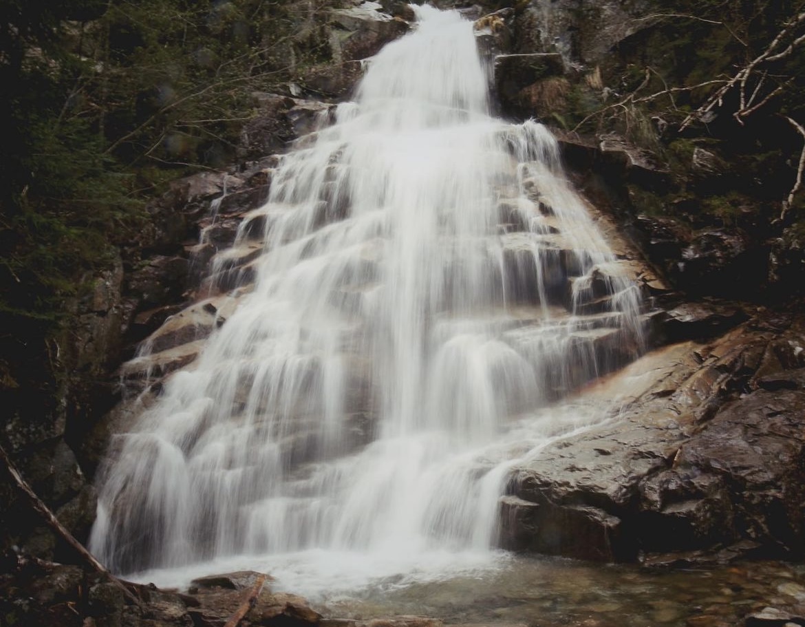
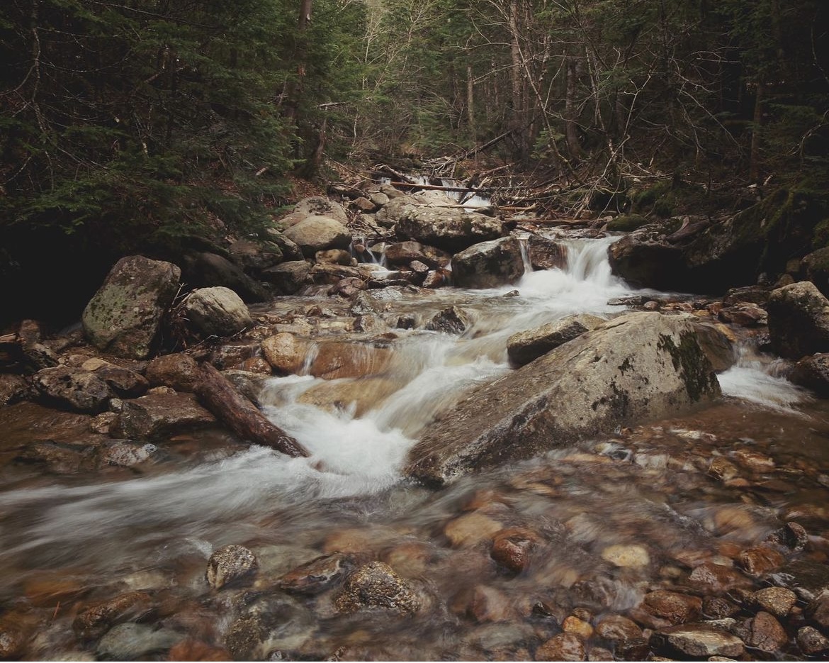
The last 1.5 miles were very relaxing. We enjoyed the 3 waterfalls-Stairs, Swiftwater and Cloudland falls. There are a few river crossings that if you’re tired or there’s been heavy rains, can be tricky. I wanted to grab some photo’s of the falls and actually ended up slipping on a rock and into the water. Thankfully, it was shallow and I managed to stay pretty dry. The final 0.2 miles of the hike rejoin with the Old Bridle Path. You’ll continue down it until you hit the parking lot.
What I wore:
Camelbak Cloud Walker 18 liter pack (old version)
Arc’teryx Atom LT Hoody (2018 version)
Wore 1 base layer to start
Columbia Montrail Windproof Pants (they don’t make these anymore but REI has some good alternatives)
Wool headband
Wool socks
Danner 600
2L of water in a hydration bladder
What I packed:
Extra mid-layer
1 pair of gloves
Safety blanket
Extra pair of socks
Comfy shoes for post-hike drive (left in car)
Snacks: Sportbeans, cosmic brownie, pepperoni, and dried fruit
Would’ve been helpful to have:
Trekking poles
Hand warmers
Friendly tidbits:
Always check the weather in the Whites. It’s notorious for rapid changes in weather conditions.
Always start a little chilly, attire-wise. You will heat up, and you don’t want your warm layers to get wet with sweat.
Interested in the 4k footers club? Mt. Lafayette and Mt. Lincoln count!
Pets are allowed. Please be realistic and aware of the weather and steep terrain.
As always, leave no trace. Pack out what you pack in.
Closed during the fall, winter, and much of the spring. The hut cannot be used as an emergency shelter during the winter.
Parking:
In Google Maps, searching for “Old Bridle Path trailhead” should bring you to the correct spot (GPS coordinates: 44°08’31.8″N 71°40’53.6″W).
Across Route 93 is Lafayette Place Parking, an alternative parking area if the Trailhead parking is full.
There is also a hiker shuttle that runs to the trailhead from the Peabody Big Lot for a small, cash-only, fee. More information can be found on the Franconia Notch State Park website.